BC Cycling infrastructure news
-
Trail of the Okanagans
[This project connects Gap B - Goats Peak Park to Peachland on the Trail of the Okanagans map, big achievement! - Skye]
Multi-use trail connecting West Kelowna, Peachland was 25 years in the making
https://www.trailoftheokanagans.com/new-page-1
Some 25 years after the idea was conceived, cyclists and pedestrians can now travel between West Kelowna and Peachland without risking injury on Highway 97, thanks to the Peachland to West Kelowna Multi-Use Trail, which celebrated its grand opening.
The 2.7-kilometre-long path links West Kelowna from Seclusion Bay to Peachland and offers users not only safe passage, but also sweeping views up and down Okanagan Lake.
The connecting trail has been a long time coming.
The Gellatly Bay Trails and Parks Society was asked to bring a trail to Peachland 25 years ago, said Bruce Dalrymple, the society’s president and a retired engineer with a love of the outdoors.
“We couldn’t, because Goat’s Peak was not a park. It was private property,” said Dalrymple.
When Goat’s Peak opened in 2015, the society began working with Peachland and the Ministry of Transportation and Infrastructure to put the trail through.
It was a challenge to find a design that the Ministry of Transportation would accept; however, what was once a deer trail is now a 10-foot-wide path built with 6,000 tonnes of crushed gravel.
Peachland Mayor Patrick Van Minsel said the $2 million project was funded by over $920,000 from the B.C. Active Transportation Grants Program, $356,000 from the federal Communities’ Active Transportation Fund, and $400,000 from the District of Peachland. The Ministry of Transportation and Infrastructure donated fill as well as highway barriers. “Now we’ve got to encourage people to use it,” said Garry Wittich of the Gellatly Bay Trails and Parks Society. “Once they come out and see what a beautiful job the contractor has done, I think they’ll use it a lot.”
Craig Thompson was part of a group of cyclists that pedaled from Heritage Park in Peachland for the official opening. “It took us about 20 minutes,” he said. “Depending on the type of bicycle you’re riding, you have to work at it.” It was Thompson’s first time cycling the trail, but he can see himself riding it frequently. “I think it’s fantastic for the community and for being able to connect West Kelowna to Peachland,” he said. “I think we need to move to a more active transport solution,” said Lloyd Stinson Sotas of the Peachland Outdoors Club. “A lot of people do commute back and forth. I think, from the business perspective too, restaurants will have a grand time on both sides, with new customers coming for a beer after they’ve had an invigorating cycle.”
The trail also represents part of the valley’s rich history.
The opening of the Peachland to West Kelowna section brings the Trail of the Okanagans Society closer to its dream of a 370-kilometre-long hiking and cycling trail from Sicamous to Brewster, Washington.
“This stretch—2.7 kilometres—may be short, but it’s very important because it’s the most technically difficult piece of the trail to build,” said Janice Liebe, president of the Trail of the Okanagans Society, an advocacy group focused on trail sections between the Bennett Bridge and the Canada–U.S. border. “It’s essential to have this piece so we can continue to build south and north, and connect all the way from Sicamous in the north to Brewster, Washington.”
The original Trail of the Okanagans, carbon-dated to be more than 6,000 years old, was a major trading route that connected the Syilx Okanagan communities.
The society is following the original trail as closely as possible as it works to stitch together more than 100 individual pieces of a fragmented linear hiking and biking pathway that exists from Osoyoos to Kelowna.
“We’re hoping today really inspires a lot of other communities to say, ‘Hey, I want to be a part of that,’” said Liebe. “The City of West Kelowna is actively working on our portion of the Trail of the Okanagans by embedding it within our Transportation Master Plan, currently in progress,” said West Kelowna Mayor Gord Milsom.
The ribbon-cutting ceremony took place at the Talking Circle, a feature designed to bring people together—where they can stop, take in the breathtaking view, picnic, drink some water, and ponder the long history of the valley.
-
Shuswap North Okanagan Rail Trail
https://shuswapnorthokanaganrailtrail.ca/
[Sicamous to Amstrong, currently being built but behind schedule due to ALC approvals. Really impressive how many groups they got to work together to make this a reality]
April 04, 2025
RAIL TRAIL UPDATE: TWO MORE SECTIONS NOW COMPLETE; MARA LAKE SECTION UNDERWAY
The Rail Trail partners—Splatsin te Secwépemc, the Columbia Shuswap Regional District (CSRD), and the Regional District of North Okanagan (RDNO)— are excited to announce that two more sections of the Splatsin te Secwépemc/Shuswap North Okanagan Rail Trail have been completed, and construction is now proceeding on the next section of trail between Sicamous and Armstrong.
Since 2015, trail partners have been collaborating to develop the 50-kilometre greenway for walking and cycling. This scenic trail connects the communities of Sicamous, CSRD Electoral Area E, RDNO Electoral Area F, Enderby, Splatsin, the Township of Spallumcheen, and Armstrong. It will eventually link to Vernon, Kelowna, and greenway trail initiatives linking all the way south to Osoyoos.
Recently completed sections include those between km 0.5 and km 4.4 from Sicamous and km 49.15 and km 50.15 into Armstrong. The Armstrong section is open for use, while access to the Sicamous section is restricted due to the Bruhn Bridge construction and limited trailhead parking on the west side of the Sicamous Narrows.
Construction of the next section of trail between km 4.4 and km 14.8 along Mara Lake south of Sicamous was recently awarded to Skwlax Resource Management Ltd. Construction on this section began earlier this week and is expected to take six weeks. The general scope of work will include erosion control, environmental works, culvert and drainage improvements, preparation and installation of the trail surface, fencing, crossing improvements, signage, and landscaping restoration.
Flood erosion repairs are required but will not be completed until later this year. Detailed design for the 12 erosion locations have been sent for provincial environmental review. This work is required to take place during low water at specific times when fish habitat will not be disturbed.
Longer work hours are expected between 3 pm and 10 pm to take advantage of access around Bruhn Bridge closures and still meet the construction timeline. Residents along Old Spallumcheen Road should use caution. Construction equipment will be accessing the site from the Sicamous section of the rail trail.
Yucwmenlúcwu (Caretakers of the Land) from Splatsin Development Corporation are overseeing the project with Lawson Engineering Ltd. providing engineering design and construction services.
A funding contribution from the Federal Housing and Infrastructure Canada’s Active Transportation Funding program is supporting the current project work between km 4.4 and km 14. 8.
July 2, 2025
Please note that no new trail construction or aggregate placement will occur until further notice. SDC is currently awaiting formal approval from the Agricultural Land Commission (ALC) before proceeding with any additional development on the trail.
Residents are reminded that only select sections of the trail are currently open to the public, including:
• The trail through Enderby
• The section from km 0.5 to km 14.8 heading out of Sicamous (please note: access is currently restricted due to Bruhn Bridge construction and limited trailhead parking on the west side of the Sicamous Narrows)
• The section from km 49.15 to km 50.15 into Armstrong, which remains open for use -
Metro Vancouver - HUB Cycling UnGapTheMap Update
It’s a good thing that our amazing staff and volunteers in local committees across Metro Vancouver are constantly advocating to UnGapTheMap, and they have had some great successes. Here are some of the critical gaps that have recently been “UnGapped”:
Vancouver:
In Vancouver, there are a few exciting updates. A section of the Central Valley Greenway from Clark to Victoria was upgraded, including separating people driving motor vehicles and people on bikes and improving the painted bike lane to a protected bike lane. Additionally, 14th Avenue was extended from Alder St. to the Arbutus Greenway. People riding and rolling can now take 14th Ave all the way from the Arbutus Greenway in the west to King Edward St bikeway in the east. 14th Ave bikeway is a key east-west connection in the gap between the 10th Ave and the 29th Ave bikeways.Burnaby:
A new multi-use pathway was constructed on Gilmore Avenue, filling a critical gap and helping UnGapTheMap for this community. Also, bike lanes on Southpoint Drive and 18th Ave were upgraded to protected bike lanes, strengthening the Edmonds area bike network.Delta:
The Barns to Beaches route is slated to open June 1, 2025. The route links breweries and farm stands in Ladner with cafes and beaches in Tsawwassen. The route includes wayfinding signs, traffic calming and bike repair stands. This route has both the potential to draw people (locals, tourists, etc) to the area, and is a significant north-south route with potential future connections to the Massey Tunnel (via MOTT's bike shuttle), BC Ferries terminal and the Great Blue Heron Way in Tsawwassen.Pitt Meadows:
A north-south Multi-Use Pathway connecting the housing and shops at Osprey Village to points north was extended.Ridge Meadows:
Two brand new Multi-Use Pathways have been completed. One on Hammond Road from 203rd to West St. A second from 203rd St to Laity Street and from 117th Ave to Lougheed Highway. -
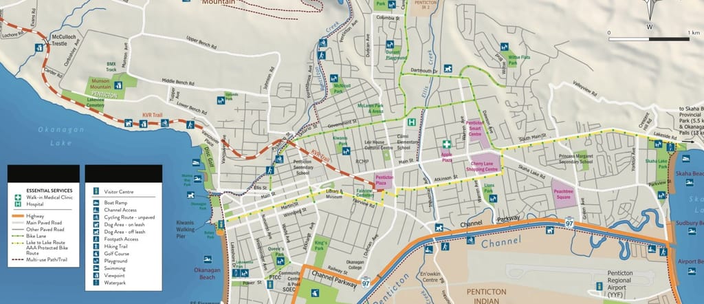
Penticton - Lake to Lake Route
https://www.penticton.ca/city-services/roads-transportation/bike-route-construction
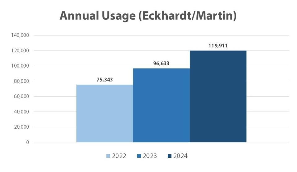
The Lake to Lake Route is now complete, with final landscaping underway and set to be completed later this fall. This protected bike lane stretches approximately 6 km through the centre of the city, intended to make cycling convenient and safe for residents of all ages and abilities.
This route provides a safe and convenient cycling option for residents of all ages and abilities, connecting Okanagan Lake to Skaha Lake. Roughly 120,000 trips were measured along the partially completed route in 2024. Also, a substantial portion of the project's funding has been provided by strong support from both provincial and federal governments. To date, they have contributed roughly 70% of the total cost.
-
I'm tracking a lot of cycling & active transportation projects around BC, would it be useful to have a thread with updates on those projects?
There's a lot going on and I find it helps keep the motivation levels up.
-
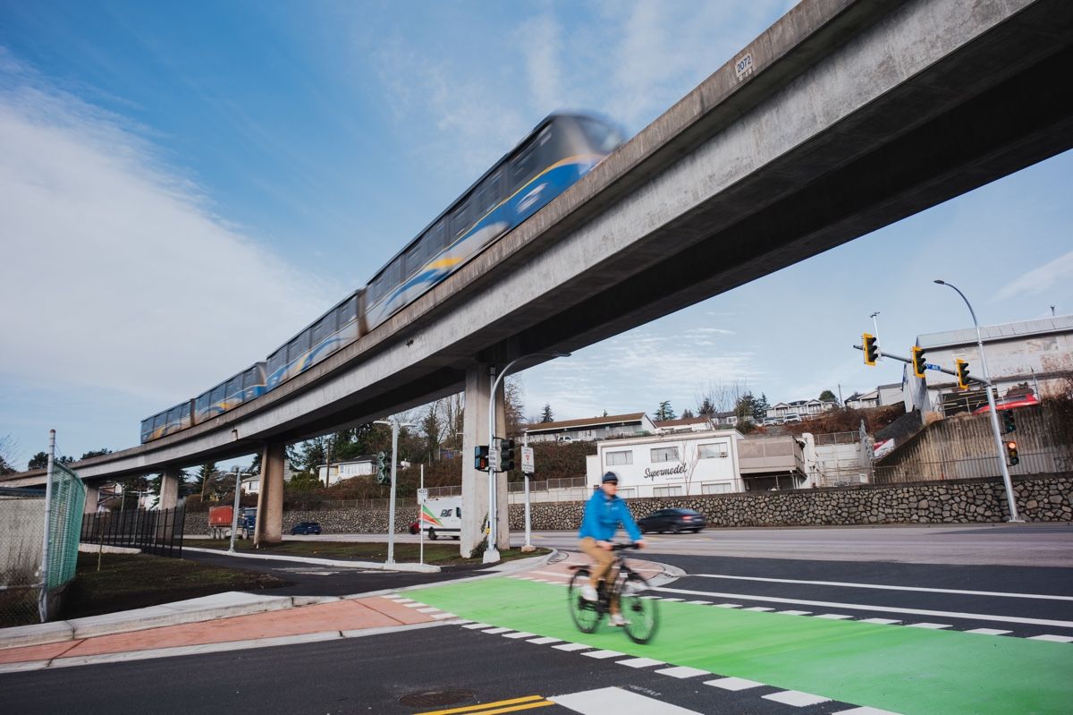
Missed this announcement from June. I visit New West often and have ridden the BC Parkway many times. While it is a separated path, the intersection crossing were very dangerous. Great to see upgrades completed with proper intersection design. New Westminster Mayor Patrick Johnstone has been really good at getting major AT projects completed.
Kamloops needs green paint at EVERY intersection where an AT route crosses!
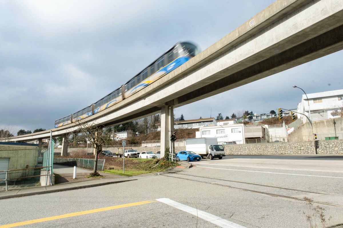
BC Parkway upgrades now complete in New Westminster
https://www.translink.ca/news/2025/june/bc parkway upgrades now complete in new westminster
NEW WESTMINSTER, BC – TransLink and the City of New Westminster have completed major upgrades to a 737-metre stretch of the BC Parkway along Stewardson Way, between River Drive and 14th Street. These enhancements are designed to improve safety, comfort, and accessibility along this vital active transportation corridor.
"Upgrades to the BC Parkway bring long-lasting benefits to communities across Metro Vancouver," says TransLink CEO Kevin Quinn. "Whether you're cycling, rolling, walking, or running, these improvements make it easier and smoother to choose active transportation every day.”
Key upgrades include:
- A widened pathway with separate lanes for cyclists and pedestrians making it comfortable and convenient for all modes of active transportation
- Improved lighting and street-level visibility for public safety
- Greater separation between BC Parkway and heavy vehicle traffic on Stewardson Way for improved comfort
- Safety upgrades to the intersection of Stewardson Way and River Drive, Stewardson Way and 5th Avenue, and Stewardson Way and 14th Street
"The completion of the BC Parkway renovations fills an important transportation gap in our community," says New Westminster Mayor Patrick Johnstone. "In working together, we have transformed this vital connection, improving safety and comfort of all road users. These improvements are a testament to our shared commitment to creating a safer and more connected community for everyone."
This project aligns with New Westminster City Council’s 2023-2026 Strategic Priorities Plan by improving the safety and accessibility of a key transportation route. It also meets the City’s Active Transportation Network Plan objectives to improve the safety, comfort, and convenience of active transportation infrastructure.
The upgrades were made possible through collaboration with Southern Railway of British Columbia, which provided access to a key section of land, and is funded by TransLink with contributions from the City of New Westminster.
Before:
After:
-
A Adam Admin moved this topic from General Public Discussion